GIS Technology Solutions for Smarter Community Lead Lateral Replacements
 Written by: Ryan Eckdale-Dudley, Mead & Hunt
![]()
Everyone deserves access to safe and clean drinking water. However, many service lines connecting the water supply to homes and other buildings still contain lead that contaminates the drinking supply for the most vulnerable people within our communities. Cities and towns across Wisconsin seek expanded access to safer, cleaner water, particularly in disadvantaged neighborhoods.
Advances in Geographic Information System (GIS) Mapping technology offer innovative solutions to bring clean, safe drinking water to every household.
Mead & Hunt’s One Water Group partners with communities to manage complex initiatives and help guide municipalities on how to remove lead service lines (LSL) from our aging infrastructure. LSL replacement presents considerable challenges around documenting, updating, and sharing asset information.
Recently, our GIS Team partnered with the City of Oconomowoc (the City) to streamline a process to replace the City’s LSLs. An integral part of any LSL replacement program is inventorying service line locations and their respective pipe material—specifically lead—so utilities can better understand, plan for, and manage the replacement activities. Unfortunately, complete and accurate information about the pipe material is often unknown. The City’s Water Utility Department soon recognized significant gaps and inefficiencies in their existing datasets and replacement documentation practices. To overcome this challenge, our GIS specialists found a solution: a novel collaboration with Esri, a GIS mapping software provider.
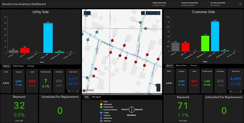
 Esri’s ArcGIS Field Maps application inventories and validates construction materials used to pipe city water to households using field apps and mobile data collection. This allowed field workers to easily flag LSLs targeted for removal. Custom dashboards helped visualize and monitor replacements and regulatory compliance so that the water department could easily track progress and strategize upcoming replacements. The software also provided real-time reporting that supported PSE report preparation. To keep residents informed of updates, the public-facing app allowed the team to educate the local community about program initiatives and progress. The technologies we used worked in tandem to implement a software solution for the City’s LSL program, which included precise mapping, infrastructure analysis, ongoing tracking and reporting, field mobility, and communication and outreach with stakeholders.
This cutting-edge solution helped the City of Oconomowoc identify customers with suspected lead laterals, then integrate the information with the precise street, water main, and customer datasets. Mead & Hunt’s GIS Team continues to collaborate with local governments across Wisconsin to help replace LSLs and provide safe, clean drinking water to all.
About the Guest Blogger
 Ryan Eckdale-Dudley, GIS Team Leader at Mead & Hunt, has more than 20 years of experience providing local government with strategies and impactful solutions for achieving their community initiatives. He uses GIS not just as a map, but as a transformative technology – a collection of people, data, stories, and tools – to empower clients to better manage their information, communicate initiatives, and make data-driven decisions that result in optimal outcomes.
Founded in 1900, Mead & Hunt—a full-service architectural, engineering, and construction firm—has since expanded significantly in size and geographic reach.